Google-Backed Satellites for Wildfire Detection Launch as Smoke Chokes US and Canada

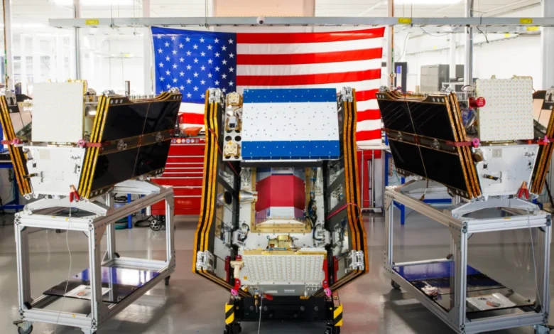
As thick plumes of smoke from hundreds of active wildfires continue to drift across the North American continent, obscuring skylines and triggering air quality alerts for millions, a significant technological milestone in disaster management has been reached. On July 7, 2026, the first three operational satellites of the FireSat constellation were successfully deployed into orbit, marking a new era in the global effort to detect and manage wildland fires. Launched aboard a SpaceX Falcon 9 rocket from Vandenberg Space Force Base in California, these microsatellites represent the vanguard of a dedicated orbital network designed specifically to identify nascent blazes before they escalate into uncontrollable conflagrations.
The deployment comes at a critical juncture. For weeks, massive fires in Canada’s boreal forests have generated smothering smoke clouds that have descended upon major metropolitan areas in both the United States and Canada, impacting the health of over 100 million people. The FireSat program, managed by the nonprofit Earth Fire Alliance and heavily supported by Google and the Bezos Earth Fund, aims to provide fire agencies with the high-resolution, high-frequency data necessary to combat these increasingly frequent and intense climate-driven events.
The Vandenberg Deployment and Initial Operational Capability
The successful launch on July 7 is the culmination of years of development and testing. These three microsatellites are the first of a planned constellation that will eventually exceed 50 units. According to the Earth Fire Alliance, this launch signals the transition to "initial operational capability." Following a rigorous three-month commissioning and testing phase, the satellites will begin transmitting real-time data to fire-fighting organizations across the globe.
By the end of 2026, the satellites are expected to provide comprehensive coverage of every fire-prone region on Earth at least twice per day. This initial cadence is designed to support fire agencies in high-risk zones, including California, Colorado, Australia, and Portugal—regions that have faced devastating fire seasons in recent years. The satellites were manufactured by Muon Space, a California-based firm specializing in climate-focused satellite constellations, and are equipped with advanced sensors specifically tuned to the thermal signatures of wildland fires.
A Paradigm Shift in Remote Sensing Technology
Current wildfire detection often relies on multi-purpose weather satellites, such as the MODIS (Moderate Resolution Imaging Spectroradiometer) and VIIRS (Visible Infrared Imaging Radiometer Suite) instruments. While invaluable, these systems were not built solely for fire detection; they often have lower resolution or longer revisit times, meaning small fires can grow significantly before they are spotted from space.

FireSat breaks this mold by utilizing multispectral imaging capable of peering through dense smoke and cloud cover. The most striking capability of the FireSat sensors is their resolution: they can detect fires as small as five by five meters (approximately 16 by 16 feet). This precision allows for the identification of low-intensity blazes that remain invisible to existing orbital infrastructure.
The effectiveness of this technology was demonstrated by the FireSat Protoflight satellite, which launched in March 2025. During its testing phase, the protoflight captured more than one million images, proving it could identify small, smoldering fires in remote areas. This early detection is vital because the cost and difficulty of suppressing a wildfire increase exponentially as the fire grows. Identifying a blaze while it is still a small "spot fire" allows agencies to deploy rapid-response teams or aerial assets to contain the flame before it reaches the crown of the forest or threatens residential communities.
Funding and Strategic Partnerships
The FireSat initiative is a prime example of a public-private-nonprofit partnership. The Earth Fire Alliance, the nonprofit overseeing the project, has secured substantial backing from some of the world’s largest philanthropic and technology entities. Google has been a primary supporter, contributing over $15 million to facilitate the initial deployment and provide technical expertise through Google Research.
In addition to Google’s contributions, the Bezos Earth Fund committed $26 million to the project, recognizing it as a critical tool for global climate resilience. These funds have been instrumental in moving the project from the conceptual phase to the current operational launch. The involvement of Google is particularly significant due to the integration of artificial intelligence. Google Research is applying advanced AI models to the FireSat data stream, comparing real-time imagery with vast archives of historical data to distinguish between actual fire starts and "false positives" like industrial heat signatures or reflections.
Operational Timeline and Global Expansion
The July 2026 launch is only the beginning of a phased rollout intended to provide near-continuous global monitoring. The Earth Fire Alliance has outlined a clear roadmap for the constellation’s expansion:
- Late 2026: The first three satellites begin delivering data to the "early adopter" cohort, which includes fire agencies in the U.S., Europe, and Australia.
- 2029: As more satellites are launched, the program aims to achieve an hourly revisit rate for any location on Earth.
- Early 2030s: The full constellation of over 50 satellites is expected to be in orbit, providing updated imagery every 20 minutes.
This 20-minute revisit rate is considered the "holy grail" of wildfire remote sensing. It would allow fire managers to track the movement and behavior of a fire in near-real-time, providing actionable intelligence for evacuation orders and the strategic placement of firefighting resources.

Quantifiable Benefits to Climate and Economy
The justification for the FireSat program is rooted in stark economic and environmental data. Wildfires are not only a threat to life and property but are also major drivers of carbon emissions. The Earth Fire Alliance projects that even with an hourly revisit rate, the constellation could save more than $1 billion in fire damage and suppression costs annually.
Furthermore, the environmental impact is profound. Early detection and suppression are estimated to prevent nearly 22 million tons of carbon emissions per year—roughly equivalent to the annual emissions of several million passenger vehicles. In terms of land preservation, the program aims to protect 1.3 million acres of land and approximately 3,500 homes every year that would otherwise be lost to runaway blazes.
The Growing Crisis in the North: Canada’s Boreal Forests
The urgency of the FireSat mission is underscored by the current situation in Canada. The country is experiencing a trend of increasingly destructive fire seasons, with 2023 and 2025 ranking among the worst on record. As of mid-July 2026, Canada has already recorded over 3,600 wildfires, burning more than 6.6 million acres.
Climate scientists have warned for decades that the boreal forests of the North—a massive carbon sink—are becoming more vulnerable as the world gets hotter and drier. These forests are now burning with a size and intensity that overwhelms traditional fire suppression strategies. Werner Kurz, a retired senior research scientist at Natural Resources Canada, noted that the current situation is exactly what models predicted: as the climate shifts, old strategies are simply being overwhelmed by the sheer scale of the blazes.
In many remote regions, fire agencies are forced to make the difficult decision to monitor "out of control" fires rather than fight them, due to limited resources and the extreme risks posed to firefighters. In this context, FireSat’s ability to provide constant monitoring of these remote fires is invaluable, allowing agencies to focus their limited aerial tankers and heavy-lift helicopters on the blazes that pose the greatest risk to human life and critical infrastructure.
The Paradox of High-Tech Solutions and Climate Change
While the FireSat program represents a major step forward in climate resilience, it also highlights a complex tension within the technology sector. Google’s celebration of the launch as a "tangible step forward in putting practical AI to work" comes at a time when the company’s own environmental footprint is under scrutiny.

The buildout of massive AI data centers requires immense amounts of electricity. In 2025 alone, Google’s company-wide electricity usage grew by 37 percent. Much of the new demand for data center power in the United States is being met by natural gas projects, which could collectively emit more than 129 million tons of greenhouse gases per year. This creates a paradox where the tools used to detect and mitigate the symptoms of climate change (such as wildfires) are powered by processes that contribute to the underlying cause of global warming.
Google has acknowledged these challenges, citing the difficulty of deploying clean energy projects at a pace that matches the energy-hungry growth of AI. Nevertheless, the company maintains that the long-term benefits of AI-driven climate solutions, like FireSat, are essential for a world already dealing with the consequences of a changing atmosphere.
Implications for Global Fire Management
The launch of the FireSat constellation is likely to change how nations cooperate on disaster response. By providing a global, democratized data stream, the Earth Fire Alliance ensures that even nations with fewer resources for their own space programs can access high-quality wildfire intelligence.
However, technology alone is not a panacea. Experts emphasize that detection is only the first step. To be effective, the data from FireSat must be integrated into robust ground-level responses, including increased funding for prescribed burns, ecosystem management, and the procurement of firefighting aircraft. In Canada, the federal government has recently moved to lease new aerial firefighting assets to support provinces, but many argue that a more comprehensive, national strategy is needed to keep pace with the "new normal" of the wildfire crisis.
As the first three FireSat satellites begin their journey around the Earth, they carry the hopes of fire agencies, atmospheric scientists, and the millions of people living in the shadow of the smoke. While they cannot extinguish the flames themselves, they provide the "eyes in the sky" necessary to ensure that the fires of the future do not go unnoticed until it is too late.