Google-Backed FireSat Satellites Launch to Revolutionize Early Wildfire Detection Amidst Escalating Global Climate Crisis

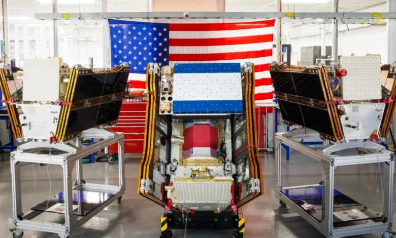
As thick plumes of smoke from hundreds of uncontrolled wildfires continue to blanket vast regions of Canada and the United States, a significant technological milestone in climate resilience was achieved this week. On July 7, 2026, the first three operational satellites of the FireSat constellation were successfully deployed into orbit, marking the beginning of a new era in orbital wildfire monitoring. Launched via a SpaceX Falcon 9 rocket from Vandenberg Space Force Base in California, these microsatellites represent a pivot toward high-frequency, high-resolution detection designed to identify blazes long before they escalate into catastrophic infernos.
Managed by the nonprofit Earth Fire Alliance (EFA) and bolstered by significant technical and financial backing from Google, the FireSat program aims to fill a critical gap in current Earth-observation capabilities. While existing government-operated satellites provide essential data on large-scale weather patterns and major thermal anomalies, they often lack the resolution or revisit frequency required to spot small, nascent fires in remote areas. The FireSat constellation is specifically engineered to address this "detection gap," providing fire agencies with the intelligence needed to intervene during the crucial early stages of a wildfire’s life cycle.
Technical Specifications and Orbital Capabilities
The three satellites launched this month are the first of a planned constellation that will eventually number more than 50 units. Developed by California-based satellite manufacturer Muon Space, these microsatellites utilize advanced multispectral imaging technology. Unlike standard optical cameras, which are often blinded by the very smoke a fire produces, FireSat’s sensors can peer through smoke and moderate cloud cover to detect heat signatures on the ground.
The most transformative aspect of the FireSat technology is its resolution. The sensors are capable of detecting fires as small as five by five meters (approximately 16 by 16 feet). For context, traditional wildfire-monitoring satellites, such as those utilizing the VIIRS (Visible Infrared Imaging Radiometer Suite) or MODIS (Moderate Resolution Imaging Spectroradiometer) instruments, typically operate at resolutions ranging from 375 meters to one kilometer. By providing a resolution orders of magnitude finer than existing systems, FireSat can identify a single burning tree or a small campfire-sized blaze in the middle of a dense forest.

This capability was rigorously validated through the "FireSat Protoflight," a test satellite launched in March 2025. Over its year-long evaluation period, the Protoflight captured more than one million images, proving its ability to detect low-intensity "cool" fires that were invisible to larger, more distant satellites. The three new satellites now in orbit represent the move to "initial operational capability," with a three-month commissioning phase currently underway to calibrate sensors and integrate data streams with global fire management agencies.
A Chronology of the FireSat Initiative
The journey to this month’s launch began several years ago as a collaborative effort between the tech industry, environmental nonprofits, and the aerospace sector.
- 2023–2024: The Earth Fire Alliance was formed as a nonprofit entity to oversee a dedicated wildfire constellation, recognizing that government agencies were struggling to keep pace with the increasing frequency of "mega-fires."
- September 2024: Google announced its formal partnership with the EFA, committing over $15 million in funding and the expertise of Google Research to develop AI models for fire detection.
- March 2025: The FireSat Protoflight was launched, serving as a proof-of-concept for Muon Space’s sensor technology.
- Late 2025: The Bezos Earth Fund joined the initiative with a $26 million commitment, accelerating the manufacturing timeline for the first operational batch of satellites.
- July 7, 2026: The first three operational satellites reached orbit, beginning the transition from experimental testing to real-world fire suppression support.
- 2026–2029: The program plans to launch additional batches of satellites to achieve a revisit rate of once per hour for every fire-prone region on the planet.
- Early 2030s: The full constellation of 50+ satellites is expected to be operational, providing global imagery every 20 minutes.
Financial Backing and Strategic Partnerships
The FireSat program is a prime example of the growing "space-for-earth" economy, where private capital and philanthropic interests fund infrastructure traditionally reserved for national space agencies. Google’s contribution extends beyond the $15 million in direct funding; the company’s AI researchers are actively building the software infrastructure that will process the deluge of satellite data. By comparing real-time FireSat imagery against a massive archive of historical satellite data, Google’s AI can distinguish between a new fire and "false positives" like sun glint on water or industrial heat signatures.
The Bezos Earth Fund’s $26 million investment further underscores the perceived necessity of this project. In a statement regarding the commitment, the fund emphasized that wildfire detection is a cornerstone of global climate adaptation. These financial infusions have allowed the Earth Fire Alliance to offer the data to fire agencies under an "early adopter" program, which currently includes specialized units in California, Colorado, Australia, and Portugal. These regions were selected due to their high risk of seasonal wildfires and their advanced capabilities for rapid-response firefighting.
Economic and Environmental Projections
The Earth Fire Alliance has released detailed projections regarding the potential impact of a fully realized FireSat constellation. The nonprofit estimates that achieving an hourly revisit rate could save the global economy more than $1 billion annually in fire-related damages. Beyond the direct protection of property, the environmental stakes are equally high.

Wildfires are a major contributor to the global carbon cycle. The EFA projects that early detection could prevent the release of nearly 22 million tons of carbon emissions per year by allowing firefighters to contain blazes before they reach a size where they produce their own weather systems. Furthermore, the program aims to protect an estimated 1.3 million acres of land and 3,500 homes annually. By reducing the size and intensity of fires, the program also helps preserve biodiversity and protects critical watersheds that are often devastated by the post-fire erosion and runoff common in scorched landscapes.
The AI Paradox: Climate Resilience vs. Carbon Footprint
While Google’s involvement in FireSat is hailed as a breakthrough for "practical AI," it also highlights a growing tension within the technology sector. The very AI models required to process FireSat’s data and provide predictive modeling are hosted in massive data centers that require immense amounts of electricity.
In its 2025 environmental report, Google acknowledged that its company-wide electricity usage grew by 37 percent in a single year, largely driven by the expansion of AI infrastructure. Much of this new demand is being met by natural gas projects, which could emit upwards of 129 million tons of greenhouse gases annually across the industry. This creates a complex narrative: tech giants are providing the tools to manage the symptoms of climate change (such as wildfires) while their core business operations continue to contribute to the underlying cause (greenhouse gas emissions).
Nevertheless, Google Research maintains that the benefits of "climate resilience AI" are tangible. By providing fire agencies with a "god’s eye view" of the forest floor, AI can help optimize the deployment of limited resources, ensuring that water bombers and ground crews are sent where they can do the most good.
The Current Crisis: A Stark Reminder of the Stakes
The timing of the FireSat launch is poignant. As of mid-July 2026, the Canadian Wildland Fire Information System reports nearly 900 active wildfires across the country, with dozens classified as "out of control." To date, over 6.6 million acres have burned in Canada this year alone. The resulting smoke has triggered air quality alerts for more than 100 million people across North America, forcing evacuations in First Nations communities and straining healthcare systems in major urban centers like Toronto, New York, and Chicago.

Experts like Werner Kurz, a retired senior research scientist at Natural Resources Canada, argue that the "old strategies of fire suppression are simply being overwhelmed." As the planet warms, forests are becoming drier and more susceptible to lightning strikes and human-caused ignitions. Traditional firefighting resources—such as the 10 new aerial firefighting aircraft recently leased by the Canadian government—are often stretched thin, forced to prioritize the protection of human life and infrastructure over remote forest ecosystems.
Broader Implications and Future Outlook
The deployment of FireSat signals a shift in philosophy for global fire management. For decades, the focus has been on suppression—putting out fires after they have already become large enough to be noticed by ground observers or civil aviation. FireSat shifts the focus toward "early intervention," treating wildfires like a medical emergency where every minute of delay increases the risk of a catastrophic outcome.
However, detection is only the first step. For FireSat to be truly effective, the data must be integrated into a robust "detect-to-suppress" pipeline. This requires international cooperation, as smoke and carbon emissions do not respect national borders. The Earth Fire Alliance’s decision to include international cohorts from Australia and Portugal is a step toward a globalized response.
As the first three operational FireSat satellites begin their mission, the eyes of the global climate community are watching. If the program can successfully demonstrate that orbital AI can reliably catch small fires before they become "mega-fires," it may provide a template for other satellite constellations dedicated to monitoring methane leaks, illegal logging, and other drivers of the climate crisis. For now, the focus remains on the ground, where firefighters in the boreal forests of Canada and the dry scrublands of the American West await the first actionable data from this new orbital sentinel.